Wednesday, November 9, 2016

Plans to burn 80 acres of slash piles in the Ochocos this week

The Ochoco National Forest plans to burn around 80 acres of downed wood debris this week in the area of Rush Spring, 25 miles northeast of Prineville, and about 2 miles south of Highway 26 and the Mark’s Creek subdivision along Forest Service Road 2620.

Weather conditions permitting, the ignitions would start tomorrow, Thursday, November 10, in the morning, and last one or two days. Smoke is expected to be visible along the Highway 26 corridor, but no other impacts to traffic or nearby residences are expected.

The slash is left over from previous thinning treatments. Fire managers plan to burn the material this week in order to reduce the heavy fuel loading and prepare the area for a previously-planned prescribed burn at some point in the future.


Thursday, November 3, 2016

Juniper jackpot burning takes place today and tomorrow near Rager RS on Ochoco NF

Juniper jackpot burning will take place today and tomorrow on around 175 acres near Rager Ranger Station.

Jackpot burning addresses high concentrations of naturally-occurring or thinning-related downed woody debris (not piled).

The units are located approximately 15 miles northeast of Paulina, in the vicinity of Rager Ranger Station and Bear Butte.

The burning of this juniper will provide better connectivity of sage grouse habitat, improve critical winter range for big game and simultaneously reduce hazardous fuel loading to lower the risk of large scale wildfire across the landscape.

Ignitions will last 3 to 5 days with smoke being visible in the area for several days following. Smoke will be visible from Forest Service Road 58 and the Post/Paulina Highway. Roads will have signs posted, but no delays are expected.

This burning project is made possible by funding from the Rocky Mountain Elk Foundation.


Thursday, October 20, 2016

Pile burning planned for the National Grassland and Ochocos

 With the onset of recent precipitation across Central Oregon, fire managers on the Crooked River National Grassland and the Ochoco National Forest will begin pile burning this week, and will continue seeking opportunities throughout the fall and into the winter.

Tomorrow, (Friday, October 21) firefighters will ignite 68 acres of hand piles located at the base of Grizzly Mountain along Highway 26 between Madras and Prineville.

The juniper slash is left over from a thinning project and commercial firewood sale along the southern boundary of the Grassland, near Mile Post 16, about 8 miles northwest of Prineville.

Objectives for the burn are simply to remove leftover juniper slash material so land managers can reseed the area with native grasses.

Light smoke will be visible for one day during active ignitions, but is not expected to impact the highway or passing motorists.

Following this burn, managers will seek an opportunity to burn slash piles within the Bailey Butte fire salvage area, near Ochoco Divide, just east of Highway 26.

Fuels specialists follow policies outlined in the Oregon Smoke Management Plan, which governs prescribed fires (including pile burning) and attempts to minimize impacts to visibility and public health.

Fire managers are planning these pile burns in coordination with Crook County Fire and Rescue and in observance of the weather and applicable air quality advisories.


The Forest and Grassland appreciate public tolerance of temporary smoke conditions in support of this work.


Friday, October 14, 2016

Pile burning begins on the Deschutes National Forest


Central Oregon–Recent rain and snow accumulations coupled with cool fall temperatures will allow fuels specialists across the Deschutes National Forest to begin burning slash piles. 

Beginning next week, and continuing through the next several weeks and months depending on conditions, specialists will begin burning a variety of units across the forest starting in the southern end of the forest on the Crescent Ranger District.

Piles may smolder, burn, and produce smoke for several days after ignition.  While smoke may linger in the area, there is a real benefit to burning this type of vegetation.  The piles are concentrations of leftover materials associated with previous vegetation management activities intended to remove hazardous fuels that can burn during summer wildfires. 

No closures are anticipated with these operations.  However, if smoke drifts on to roads, motorists should slow down, turn on headlights, and proceed with care.  Once ignited, units are monitored by firefighters until they are declared out.

Fuels specialists follow policies outlined in the Oregon Department of Forestry smoke management plan, which governs prescribed fires (including pile burning) and attempts to minimize impacts to visibility and public health.

For more information, visit the Deschutes website at www.fs.usda.gov/deschutes and follow us on twitter @CentralORFire. 


-End-

Tuesday, October 11, 2016

Upper Beaver prescribed burn planned for Ochocos this week

PRINEVILLE, Ore.— Fire managers on the Ochoco National Forest will take advantage of recent moisture to start working on the Upper Beaver prescribed burn tomorrow on the Paulina Ranger District.

The Upper Beaver burn unit totals about 3,800 acres, located 13 miles north of Paulina in the Tamarack Butte area. Ignitions are expected to last 5 to 7 days.

Plans call for hand lining a northern boundary along Forest Road 300, just south of Black Canyon Wilderness near Wolf Mountain Lookout and the South Prong trailhead. Once the hand lines are complete, firefighters will look for opportunities to ignite portions of the unit using either hand or aerial ignitions.

Objectives for the burn are to improve the natural resources within the unit by reducing hazardous fuels and improving big game habitat while restoring fire to a fire-adapted ponderosa pine ecosystem.

Smoke will be visible during periods of active burning, and could impact adjacent forest roads, or Mud Springs and Frazier campgrounds, and the nearby community of Paulina. The timing of the burn will fall between deer and elk hunting seasons in order to impact hunters as little as possible.

Visit our “Prescribed Fire in Central Oregon” map online to see an exact location of the proposed burn: http://www.fs.fed.us/r6/webmaps/deschutes/cofms-rxfire/
Prescribed burning is part of a Forest Service program to remove hazardous fuels in order to reduce the potential for high-intensity uncharacteristic fire, while restoring low intensity fire to a fire-adapted ecosystem and improving range and forest health.

Prescribed burning is a proactive approach to fire management, reintroducing fire in a planned, low intensity manner that benefits the resources, instead of waiting for an unplanned ignition, such as lightning, to start a wildfire that requires an expensive suppression response and can burn with destructive intensity.

The Forest Service appreciates public tolerance of increased smoke and vehicle traffic in support of these restoration goals.

For more information on prescribed burning plans, or to be added to a burning notification list, contact Assistant Fire Management Officer Sam Pearcy at (541) 416-6428 or spearcy@fs.fed.us.


For media inquiries, contact Patrick Lair at (541) 416-6647 or plair@fs.fed.us.


Friday, October 7, 2016

Industrial Fire Precaution Levels Drop to 1

Fire Danger Level is Lowered to ‘Moderate’

BEND– Fire officials have seen an overall cooling trend in Central Oregon with reduced fire activity in addition to localized precipitation, have lowered the Industrial Fire Precaution Level has dropped down to 1.

The Prineville District Bureau of Land Management, the Deschutes and Ochoco National Forests and the Crooked River National Grassland are have also lowered the Fire Danger level to MODERATE.

The Industrial Fire Precaution Level (IFPL), which regulates permitted and commercial activities on federal lands, has dropped to a Level I. Under this level, commercial and personal woodcutting is allowed at any time of day, although firewood cutters are still encouraged to be mindful and prepared for any unintentional ignitions from equipment.

Officials want to remind the public that using explosive target material, such as Tannerite, explosives, and fireworks continue to be prohibited on all federal lands.

Fire Officials want to remind people recreating on public lands to continue to use caution because while the weather has moderated, wildfires are still possible. All campfires, including warming fires used by hunters, should be cold to the touch when not being watched. Every fire that’s prevented protects our communities and helps our firefighters remain available, rested, and safe.



-End-

Monday, October 3, 2016

East Maurys Closure Area Reduced

The East Maury Fire Closure Area has been reduced to allow the public access to more National Forest System lands.

As fire containment grows and the potential for fire spread is reduced, forest managers have decided to reduce the closure area to the immediate vicinity of the fire.

The only campground within the closure area is Elkhorn campground.

View the updated Closure Order and Map online: http://www.fs.usda.gov/alerts/ochoco/alerts-notices/?aid=36889


The East Maury fire is now mapped at 1,561 acres and 38 percent containment, with about 90 acres on private land.

Around 127 personnel remain assigned to the incident, including a Type 1 and a Type 2 hand crew, 14 engines, 3 dozers, and 4 water tenders.


Saturday, October 1, 2016

East Maury Mountains fire update - Saturday, October 1

Firefighters worked through the night last night to complete burnout operations and strengthen containment lines around a wildfire near Elkhorn campground in the Maury Mountains.
Crews have surrounded the entire fire with dozer and hand line and will continue burnout operations today in order to prevent further spread of a fire that moved from National Forest land onto nearby private property Thursday afternoon.
The fire size is currently estimated at 1,700 acres and 25 percent containment, with roughly 200 acres located on adjacent ranch land.
The firefighting response has been a cooperative effort between the US Forest Service, BLM, Oregon Department of Forestry, the Post-Paulina Rangeland Protection Association and the private land owners. Numerous crews, engines, and dozers remain on scene in addition to aerial support.
The fire began as a prescribed burn conducted to improve range and forest health within a 333-acre unit on the Ochoco National Forest. An unexpected wind event associated with storm movement from the south created an unforeseen wind reversal Thursday afternoon, pushing fire north across planned containment lines and creating a wildfire.
The Ochoco National Forest has issued a temporary area closure to prevent hunters and other visitors from entering the fire suppression area.


Friday, September 30, 2016

Temporary Closure in effect for Maury Mountains

A temporary closure is in effect for part of the Maury Mountains on Ochoco National Forest while crews complete a wildfire suppression. The closure is expected to last through the weekend.

View the Closure Order and Map here:  http://www.fs.usda.gov/Internet/FSE_DOCUMENTS/fseprd520020.pdf


Fall Prescribed Burning Begins on the Deschutes National Forest


BEND– Cooler temperatures and shorter days have created an opportunity for fuels specialists on the Deschutes National Forest to begin prescribed burning season. If conditions remain favorable, fuels specialists will begin burning as early as next week.

On Tuesday and Wednesday, fuels specialists on the Bend-Fort Rock Ranger District are planning three prescribed burns south of Bend. A 175 acre unit called “Pit 18” is on the west side of Wake Butte is slated for ignitions, while “Pit 12” and “Myst 12” at 75 acres and 58 acres respectively are between Fall River Campgrounds and Fall River Estates along Forest Road 42 are also planned.  For more precise locations, visit the prescribed burn live map below.

In addition to these units, there are numerous prescribed burns planned in the forest. On the Bend Fort-Rock Ranger District approximately 30 burns are planned, including three units in West Bend, five near Sunriver and four near La Pine State Park.  There are six units around Sisters slated for treatment including one near the Tollgate subdivision and one adjacent to Highway 20. Additionally, the Crescent Ranger District has seven prescribed burns planned including three around Davis Lake, three near Walker Mountain and one unit near Hamner Butte.

Any decision to move forward with prescribed burn plans will depend on appropriate weather conditions and fuel moisture, as well as adequate staffing and public notifications. All prescribed burns have been scheduled to take advantage of the cooler and more humid fall season, which moderates fire behavior to allow fuels specialists to remove hazardous fuels, reducing the potential for high-intensity uncharacteristic fire, while restoring low intensity fire to a fire-adapted ecosystem and improving range and forest health.

Fuels specialists follow policies outlined in the Oregon Department of Forestry smoke management plan, which governs prescribed fires (including pile burning) and attempts to minimize impacts to visibility and public health.

Keep up with prescribed burns in Central Oregon by visiting this live map: http://www.fs.fed.us/r6/webmaps/deschutes/cofms-rxfire/

For more information, visit the Deschutes website at www.fs.usda.gov/deschutes and follow us on twitter @CentralORFire. 


-End-

Wildfire suppression in Maury Mountains following prescribed burn

CENTRAL OREGON— Crews in the Maury Mountains are engaged in a fire suppression effort today after a wind event yesterday afternoon pushed a prescribed burn outside planned containment lines.

The Ochoco National Forest had been conducting a prescribed burn to improve the natural resources within a 333-acre unit near Elkhorn campground and Forest Road 16.

Around 4 pm yesterday, an unexpected reversal of wind direction associated with a storm system from the south pushed fire north of the burn unit and carried it onto private ranch lands. Firefighters are working with the private land owners, Oregon Department of Forestry, and the Post-Paulina Rural Rangeland Protection Association to suppress the fire on both public and private land.

The fire size is currently about 1,200 acres with an estimated containment of 20 percent. Roughly 150 acres is on private land.

Following a report of the prescribed burn moving outside planned lines, the Forest Service declared it a wildfire and responded with aggressive suppression tactics. Firefighters worked until 4 am this morning with an effort that included two heavy air tankers, two single engine air tankers, a Type 1 helicopter, and multiple crews, engines, and dozers.

The suppression effort continues today with special emphasis on implementing aggressive tactics on private land to stop the fire spread while continuing to provide safety for our firefighting personnel.

The Forest Service plans to implement an area closure on National Forest System lands to protect hunters and other visitors from entering the suppression area. The closure order and updated fire information will be released as soon as they are available.


Friday, September 23, 2016

Two prescribed burns planned for the Ochocos next week

PRINEVILLE, Ore.— Fire managers on the Ochoco National Forest plan to take advantage of recent precipitation to ignite two prescribed burns next week.

Recent moisture coupled with cooler temperatures has created an opportunity to achieve a beneficial, low intensity burn within two planned burn units.

The Rush Springs burn unit is approximately 320 acres, located about 15 miles northeast of Prineville and three miles north of Ochoco Ranger Station near Forest Service Road 2620. This burn is planned to begin Monday morning and last two days.

The East Maury burn unit is approximately 333 acres, located near Elkhorn campground along Forest Service Road 16 in the Maury Mountains, about three miles south of the Post-Paulina Highway. The East Maury burn is planned to start Wednesday and last two days.

To see exact locations of the proposed burn units, visit our “Prescribed Fire in Central Oregon” map online: http://www.fs.usda.gov/detail/ochoco/home/?cid=stelprd3812842

Prescribed burning is part of a Forest Service program to remove hazardous fuels in order to reduce the potential for high-intensity uncharacteristic fire, while restoring low intensity fire to a fire-adapted ecosystem and improving range and forest health.

Prescribed burning is a proactive approach to fire management, reintroducing fire in a planned, low intensity manner that benefits the resources, instead of waiting for an unplanned ignition, such as lightning, to start a wildfire that requires an expensive suppression response and can burn with destructive intensity.

The objectives for both the Rush Springs and East Maury burns include hazardous fuels reduction, improving big game habitat and range conditions for livestock, and reintroducing fire into a fire-adapted ponderosa pine ecosystem.

Light smoke is expected in the vicinity of each burn during periods of active ignitions, but no obstructions to road traffic are anticipated.


For more information on prescribed burning plans, or to be added to a burning notification list, contact Assistant Fire Management Officer Sam Pearcy at (541) 416-6428 or spearcy@fs.fed.us.

Wednesday, September 21, 2016

Public Use Restrictions and Industrial Fire Precaution Levels set to change on public lands in Central Oregon


Central Ore. – With consistently cooler nights, reduced fire activity around the Pacific Northwest, and a fewer human-caused wildfires recently, the Prineville District Bureau of Land Management, the Deschutes and Ochoco National Forests and the Crooked River National Grassland are lifting campfire and smoking restrictions effective 12:01 a.m. September 23, 2016 (Friday) on federal lands in Central Oregon.

For the reduction in Public Use Restrictions, open fires, including charcoal fires, will be allowed. Private lands protected by the Oregon Department of Forestry remain under a Regulated Closure at this time. Be aware that some federal sites still have campfire restrictions such as Hosmer Lake, and that the seasonal restrictions on BLM-administered lands in the following areas remain in effect:

Until September 30, 2016:
On public lands within 1/4 mile of the river’s edge in the following locations:
  • Mainstem John Day River from Tumwater Falls (River Mile 10) upstream to Kimberly (River Mile 185);
  • North Fork John Day River, from the confluence with the mainstem at Kimberly (River Mile 0) upstream to the Umatilla National Forest boundary (River Mile 62);
  • South Fork John Day River from Smokey Creek (River Mile 6) upstream to Malheur National Forest boundary (River Mile 47).
 Until October 15, 2016:
  •  Crooked River - Within ½ mile of the river’s edge along the Lower Crooked River from the Highway 97 Bridge to Lake Billy Chinook.
  • Deschutes River - Within ½ mile of the river’s edge from the Highway 20 bridge to Lake Billy Chinook; including all BLM-administered lands north of the Jefferson county line and between the Deschutes River and
  • Crooked River. Within ½ mile of Lake Simtustus (between Round Butte Dam and Pelton Dam)
  • Within the Lower Deschutes National Wild and Scenic River corridor (Pelton Dam to the Columbia River)
  •   Lake Billy Chinook - Those public lands located within ½ mile of Lake Billy Chinook; including BLM Beach dispersed recreation site located approximately ½ mile east of the Three Rivers Recreation Area on the south shore of the Metolius River Arm of the lake.
  • White River - Within ½ mile of the river’s edge from its confluence with the Deschutes River upstream to the eastern boundary of the Mount Hood National Forest.

At the same time, the Industrial Fire Precaution Level (IFPL), which regulates permitted and commercial activities on federal lands, will drop to a Level II (called a Partial Hootowl). Under this level, commercial and personal woodcutting, welding, cable yarding and blasting is allowed, where authorized, between the hours of 8:00 p.m. and 1:00 p.m. with a minimum of a one-hour fire watch following activity.

Officials want to remind the public that using explosive target material, such as Tannerite, explosives, and fireworks continue to be prohibited on all federal lands.

Officials carefully consider the current fire situation, fuel moisture and predicted weather before making the decision to lift fire restrictions. Fire Officials want to remind people recreating on public lands to continue to use caution even though fall is approaching and temperatures are cooling down; wildfires are still possible. All campfires, including warming fires used by hunters, should be cold to the touch when not being watched. Every fire that’s prevented protects our communities and helps our firefighters remain available, rested, and safe.


-End-

Thursday, September 8, 2016

Prescribed burning planned for the Ochocos this fall


PRINEVILLE, Ore.— Fuel conditions on the Ochoco National Forest are currently very dry, but as temperatures moderate and more precipitation arrives this fall, fire managers will look for opportunities to complete two large prescribed burns and several smaller ones to reduce hazardous fuels and improve forest health.

Any decision to move forward with prescribed burn plans will depend on appropriate weather conditions and fuel moisture, as well as adequate staffing and public notifications.

The two largest burns planned combine for a total of 5,000 acres and could be implemented simultaneously if conditions allow. The Ochoco National Forest wishes to make public notice of these potential burns now, so that hunters and other visitors have advanced notice of the locations and potential timing of these planned events.

The Upper Beaver burn unit totals about 3,800 acres, located 13 miles north of Paulina in the Tamarack Butte area.

The Spears burn unit totals about 1,200 acres, located 15 miles northeast of Prineville in the White Fir Springs area.

“Fall treatment of 5,000 acres is a significant prescribed fire project for us,” said Stacey Forson, Forest Supervisor for the Ochoco National Forest. “Periodic fire in these ecosystems reduces hazardous fuel build-up and greatly minimizes the risk of extreme fires in the future.”

Visit our “Prescribed Fire in Central Oregon” map online to see exact locations of the proposed burn units: http://www.fs.usda.gov/detail/ochoco/home/?cid=stelprd3812842

All access roads to the burn units have already been signed, and employees will make a sweep of the areas should conditions provide the Forest with the ability to move forward with any of the burns. Another public notice will be sent out once a proposed date is identified.

Plans call for blacklining the Spears and Upper Beaver units with hand ignitions, and then the application of aerial ignition devices delivered from a helicopter to help consume interior fuels. Ignitions are expected to last three days.

Smoke will be visible during ignitions and is expected to linger for several days. Road signs and flaggers will be used along adjacent forest roads. Smoke will be most visible along Highway 26 and Forest Roads 3350 and 500 during the Spears burn, and from Paulina and along Forest Road 58 during the Upper Beaver burn.

Prescribed burning is part of a Forest Service program to remove hazardous fuels in order to reduce the potential for high-intensity uncharacteristic fire, while restoring low intensity fire to a fire-adapted ecosystem and improving range and forest health.

Prescribed burning is a proactive approach to fire management, reintroducing fire in a planned, low intensity manner that benefits the resources, instead of waiting for an unplanned ignition, such as lightning, to start a wildfire that requires an expensive suppression response and can burn with destructive intensity.

The Forest Service appreciates public tolerance of increased smoke and vehicle traffic in support of these restoration goals.


For more information on prescribed burning plans, or to be added to a burning notification list, contact Assistant Fire Management Officer Sam Pearcy at (541) 416-6428 or spearcy@fs.fed.us

Spears burn unit


Upper Beaver burn unit


Saturday, August 27, 2016

August 27 wildfire morning update

Working through the evening yesterday, firefighters kept the Willow Fire from crossing Willow Creek and halted the fire's spread with an effort that included helicopters, air tankers, engines, and hand crews.

The fire size is now estimated at about 150 acres with 30 percent containment.

Crews will continue to suppress the fire today using three helicopters, a hotshot crew, multiple engines and other resources. Full containment is expected by tomorrow night.

The Willow Fire, located about 8 miles northwest of Madras (2 miles northeast of Pelton Dam), was reported yesterday at 1:30 pm. The emergency response includes Jefferson County and federal resources, using both structural and wildland firefighters.

The fire is deemed to be human-caused but remains under investigation.

The Lower Valley Fire, located about 8 miles west of Terrebonne off Lower Bridge Road, has been reassessed at about 50 acres. An updated containment estimate was unavailable this morning.

Firefighters worked through the night to strengthen containment lines and will continue working the fire this morning with a suppression effort that includes multiple engines, hand crews and aircraft.

The fire's cause remains under investigation.

REMINDER: Central Oregon remains in extreme fire danger and all public lands are under some level of public use restrictions.

For information about fire restrictions on federally-managed lands in Central Oregon, visit: http://centralorfireinfo.blogspot.com/2016/08/fire-restrictions-begin-in-central.html

For information about fire restrictions on state-protected lands in Central Oregon, visit: http://odfcentraloregon.blogspot.com/

Friday, August 26, 2016

Central Oregon Fire Update

Wildland and structural firefighters combined forces twice today to tackle two new wildfires in Central Oregon.

The Lower Valley fire was reported at noon today, burning about 8 miles west of Terrebonne off Lower Bridge Road, apparently started as a result of a fire that started on a hay truck. Numerous engines responded from the Forest Service and BLM, along with a structural task force made up of engines from Crook County, Sisters, Cloverdale and Redmond. Helicopters, heavy air tankers and single engine air tankers helped knock the fire down. As of this evening, the crews had stopped the forward progress of the fire and were beginning to put a hoselay around the perimeter and mop up. The fire reached about 75 acres.


The Willow Fire, burning about 8 miles northwest of Madras (2 milles NE of Pelton Dam), was reported at 1:30. As of this evening, the fire had grown to 70 acres. Crews initially focused on the east side of the fire, with structural and wildland crews working together to keep the fire from moving toward homes. Crews this evening are now working on the west side of the fire, which remains active on about 20 percent of the line. Cool temperatures this evening and rising relative humidity will help decrease fire behavior and help firefighters’ efforts. The cause of this fire is human-caused, with the specific cause under investigation. 


Central Oregon is under a Red Flag Warning tomorrow for gusty winds and low relative humidity. Fires that ignite under windy conditions can grow very quickly. Fire officials want to remind everyone that public use restrictions are now in place in Central Oregon and that campfires are limited to a short list of developed campgrounds. For a copy of that list, visit http://www.blm.gov/or/districts/prineville/fire/alerts.php

Wednesday, August 24, 2016

FIRE RESTRICTIONS BEGIN IN CENTRAL OREGON THIS WEEK


 Central Oregon – With hot and dry conditions expected to continue, increasing numbers of wildfires around the northwest, and fire suppression resources already responding to a high number of human-caused wildfires around Central Oregon, the Prineville District Bureau of Land Management, the Deschutes National Forest and the Ochoco National Forest, including the Crooked River National Grassland, are implementing campfire restrictions. 

Effective 12:01 a.m. August 26, 2016 (Friday), open fires, including charcoal fires and portable campfires, will be prohibited, except in the following designated campgrounds: 

Crescent Ranger District: Contorta Flat, Contorta Point, Crescent Lake, Simax Group, Spring, Sunset Cove, Trapper Creek, Whitefish Horse Camp, Windy Group Site, Industrial Mushroom Camp (Little Odell Butte).

Bend-Ft. Rock Ranger District: Crane Prairie, Cultus Lake, Elk Lake, Fall River, Fall River Guard Station, Gull Point, Lava Lake, Little Cultus Lake, Little Fawn, Little Fawn Group, Little Lava Lake, Mallard Marsh, North Twin, Point, Quinn Meadow Horse Camp, Quinn River, Rock Creek, Sheep Bridge, South, South Twin, West South Twin, Big River Group, Bull Bend, Wyeth, Cinder Hill, East Lake, Little Crater, Newberry Group, Ogden Group, Paulina Lake, Prairie.

Sisters Ranger District: Allen Springs, Allingham, Blue Bay, Camp Sherman, Candle Creek, Cold Spring, Driftwood, Gorge, Graham Corral, Indian Ford, Jack Creek, Link Creek, Lower Bridge, Lower Canyon Creek, Perry South, Pine Rest, Pioneer Ford, Riverside, Scout Lake, Sheep Spring, Smiling River, South Shore, Three Creek Lake, Three Creek Meadow, Three Creek Horse Camp, Whispering Pine.

Paulina Ranger District: Sugar Creek, Wolf Creek.

Lookout Mtn. Ranger District: Antelope Flat Reservoir, Deep Creek, Ochoco Divide, Ochoco Forest, Walton Lake and Wildcat. 

Crooked River National Grassland: Skull Hollow and Haystack Reservoir.

Prineville BLM: Big Bend, Castle Rock, Still Water, Lone Pine, Palisades, Chimney Rock, Cobble Rock, Post Pile, and Poison Butte.  
These restrictions do not apply to Wilderness areas on the Deschutes and Ochoco National Forests and Prineville BLM.

In addition to campfire restrictions, smoking is restricted to an enclosed vehicle or building, in a designated campground, in boats on lakes and rivers, or while stopped in an area at least three feet in diameter that is clear of all flammable material. Portable cooking stoves or lanterns using liquefied or bottled fuel may be used in all areas. 

Officials want to remind the public that using explosive target material, such as Tannerite, explosives, and fireworks continue to be prohibited on all federal lands. 

The Prineville BLM, Deschutes and Ochoco National Forests and Crooked River National Grassland have already moved to an Industrial Fire Precaution Level III (IFPL). The IFPL applies to permitted and industrial operations, including woodcutting, on federal lands. 

IFPL III is considered a “partial shutdown” and restricts the use of chainsaws to loading sites on tractor/skidder operations to between the hours of 8 p.m. to 1 p.m. Only cable yarding systems that use non-motorized systems are allowed. Industrial welding and mechanized loading operations are also restricted to the hours of 8 p.m. to 1 p.m. Industrial and permitted operations may request a waiver from the Forest Service or BLM depending on land ownership at the activity location. It is the responsibility of all operators to know and follow the requirements of the current fire precaution level.

More information about both IFPL and Public Use Restrictions can be found at http://www.fs.usda.gov/detail/centraloregon/home/?cid=fsbdev3_035880


Public use restrictions help protect the land, resources, and visitors. Officials carefully consider the current fire situation, fuel moisture and predicted weather before making the decision to implement fire restrictions. Every year lightning-caused fires place a heavy demand on our firefighting resources, and put our wildlands, our firefighters, and our communities at risk. Fires caused through carelessness or negligence only increase the threat to life and livelihood, and place an even greater burden on already busy firefighters.  Every fire that’s prevented protects our communities and helps our firefighters remain available, rested, and safe. 

Monday, August 22, 2016

Sheridan Fire and Pine Mountain Fire now Contained!

Firecrews on the Sheridan Fire burning near Sunriver and the Pine Mountain Fire east of Bend are reporting 100 percent containment on both fires today. The acreage for both fires remains the same.

Containment doesn't mean "out" so you can expect to see engines and firefighters still working in the area, along with smoke in the interior of the fire from some of the logs or brush that may still be smoldering. It's also not unusual for an occasional pocket of unburned fuel inside the fireline to burn and put up smoke.

Some of the firefighters left the Sheridan Fire and headed to fires in Washington and eastern Oregon; others will head home, rest and be ready to go out to the next new start.


Sunday, August 21, 2016

Containment Continues to Rise on Sheridan and Pine Mountain Fires

Firefighters successfully held both the Sheridan and Pine Mountain fires through the heat of the day today, and continued to improve containment lines. As of this evening, the Sheridan Fire reached 80% containment and the Pine Mountain Fire had reached 95% containment.

The Deschutes National Forest will reopen Forest Road 40 and Forest Road 45 (River Summit Road) on Monday morning at 8:00 a.m. and the Besson Day Use Area will also reopen.

As a reminder, Central Oregon has had numerous human caused fires, and fire officials are asking the public to report any suspicious activity on public lands by calling the Oregon State Police at 503-375-3555 or if it is an emergency, call 9-1-1 when they can do so safely.

Please remember when you head outdoors, that Central Oregon is currently in the peak of its fire season and the fire danger level is EXTREME


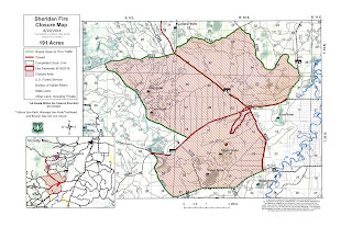
Forest Roads 40 and 45 Will Reopen to the Public on Monday: Area Closure around Sheridan Fire remains in effect

Forest Roads 40 and 45 Will Reopen to the Public on Monday
Area Closure around Sheridan Fire remains in effect

BEND– The Deschutes National Forest will reopen Forest Road 40 and Forest Road 45 (River Summit Road) on Monday morning at 8:00 a.m. Besson Day Use Area will also reopen.

Roadside hazards related to firefighting efforts have been cleared along these main routes to allow safe passage for vehicles; however, firefighters may still be working in the area and may utilize or work on these roads. Please use caution while traveling, reduce speed and do not attempt to pass fire traffic.

As a reminder, an area closure remains in effect while firefighters strengthen containment lines on the Sheridan Fire west of Sunriver, Oregon. In addition to the area closure, Wanoga and Edison sno-parks are closed to the public while they are being used to stage firefighting personnel and equipment for the Sheridan Fire.

All roads shown in green (see attached map) remain open to the public.

As the area surrounding the fire becomes safe for public use, closures will continue to be reassessed and lifted as areas become safe for public use.

The Sheridan Fire started on August 17, 2016 about 2 miles west of Sunriver, OR and swiftly grew to 191 acres in the first 24 hours. Aggressive firefighting efforts have kept the fire within planned containment lines. The cause of the fire is under investigation.


-USFS-

Public Urged to Report Suspicious Activity Related to Central Oregon Wildfires


Central Oregon – In the past month, Central Oregon has had numerous human caused fires. Now, Oregon State Police along with the U.S. Forest Service, U.S. Forest Service Law Enforcement, Bureau of Land Management, Oregon Department of Forestry and Deschutes County Sheriff’s Office believe that several of those fires were intentionally started. Specific details will not be released while investigations are ongoing.

While an investigation by all cooperating agencies is in progress, we would like to urge the public to report suspicious activity on public lands by calling the Oregon State Police at 503-375-3555 or if it is an emergency, call 9-1-1.

Central Oregon is currently in the peak of its fire season and the fire danger level is EXTREME with very dry fuels and continued hot and dry weather in the forecast. The public is reminded that every wildfire puts our firefighters, visitors, residents and properties in danger.

In addition to the arson fires, our firefighters have responded to numerous abandoned or escaped campfires. Campfires should never be left unattended and should be cold to the touch whenever they are left. Additionally, please properly dispose of cigarette butts, park only in areas clear of vegetation, and in general use caution while working and recreating.
-End-

Saturday, August 20, 2016

Firefighters Make Progress on all Three Central Oregon Wildfires

Central Ore. – Firefighters reported significant progress today on all three wildfires burning in Central Oregon:

  • Crews on Incident #516 on Tumalo Mountain across from Mount Bachelor ended the day with a report of “no smoke, no heat,” and the fire is fully contained.
  • The day shift on the Pine Mountain Fire burning east of Bend continued the work started by the night shift and held the fire at 252 acres today; the fire is now 60% contained. The Observatory and nearby campground are open.
  • Finally, fire crews on the Sheridan Fire burning near Sunriver also made gains; the Sheridan Fire remains about 200 acres and is also 60% contained. The Level 1 Evacuation for Fall River Estates and the Fall River Fish Hatchery lifted this afternoon. Fire Officials are keeping the 40, 45 and 4220 Roads closed due to the high number of hazard trees. Visitors in Sunriver trying to get to the Cascade Lakes Highway can head west from Sunriver on the 42 Road, or north from Sunriver on the 41 Road.
Much of Central Oregon is under a Red Flag Warning tomorrow for low relative humidity and increasing wind. This means that wildfires that start are very likely to spread rapidly. Low RH and wind, combined with continued warm temperatures can contribute to extreme fire behavior.  Please continue to use caution when recreating out in the woods and rangelands – make sure campfires are out when someone isn’t there to watch them, dispose of cigarettes properly, and avoid parking over vegetation.

Area Closure Remains in Effect on Sheridan Fire

Wanoga and Edison Sno-parks as well as Besson Day Use Area remain closed

BEND– The Deschutes National Forest reminds the public that an area closure remains in effect for the Sheridan Fire near Sunriver, Oregon.

Forest Road 45 (River Summit Road) between Cascade Lakes Highway and the junction of Forest Road 40 and 41 is within the closure as is Forest Road 40 from the junction of Forest Road 45 and 41 and Forest Road 4040. To access the Cascade Lakes area from Sunriver the public is encouraged to use Forest Road 42 (Fall River Road).

Besson Day Use Area has been closed to all traffic at this time. Boaters wishing to use Besson as a take-out point could use the Sunriver Resort Marina as an alternative for a $5 fee. Wanoga and Edison Sno-parks remain closed as well.

All roads shown in green (see attached map) remain open to the public.
Forest Road 41 (Conklin Road) remains open, but the public is asked to use extra caution on this road as firefighting traffic will be present. Please reduce speed and do not attempt to pass vehicles while on this road.
Forest officials will work with the incident management team fighting the Sheridan Fire to reassess the area and road closures early next week. As the area surrounding the fire becomes safe for public use, closures will be lifted.
The Sheridan Fire started on August 17, 2016 about 2 miles west of Sunriver, OR and swiftly grew to 191 acres in the first 24 hours. Aggressive firefighting efforts have kept the fire within planned containment lines. The cause of the fire is under investigation.

-USFS-

Firefighters Now Working Multiple Fires in Central Oregon

Central Ore. – Firefighters had a late night response to a new fire that started southeast of Pine Mountain. East Butte Lookout reported the new start at 8:30 p.m. at 1-acre and by this morning, the fire had reached 300 acres. Crews worked overnight with a dozer, successfully getting dozer line around 80 percent of the fire. Firefighters will work with helicopters and Single Engine Air Tankers (SEATs) to secure the remaining side of the Pine Mountain Fire (Incident #518).  Additional firefighters will work to hold and improve the dozer line put in last night.

An unknown number of people were evacuated from the Pine Mountain Observatory and nearby campground last night; the fire is approximately 2 miles from the Observatory. The cause of this fire is under investigation.

Firefighters will continue mopping up the Sheridan Fire (200 acres) burning near Sunriver, Oregon, as well as Incident #516 (1 acre plus several small spot fires) on Tumalo Mountain across from Mount Bachelor. The cause of these fires remains under investigation.

Fire officials have determined that the main roads (FS 40, 45 and 4220) through the Sheridan Fire will remain closed at this time due to hazardous trees and continued heavy fire traffic. The roads will remain closed until the snags are removed and the road is safe for travel. The Deschutes River remains open between Harper’s Bridge and the Sunriver Resort Marina; however, the closure could be reinstated if helicopters need to use the spot for dipping. The Level 1 Evacuation Notice remains in effect for homes in the Fall River Estates subdivision and the Fall River Fish Hatchery.

Continued hot and dry weather will challenge firefighters working on existing fires and increase the potential for a new start to spread rapidly. Fire officials are asking everyone to use caution when recreating out in the woods and rangelands – make sure campfires are out when someone isn’t there to watch them, dispose of cigarettes properly, and avoid parking over vegetation.

Pine Mountain Fire last night

Friday, August 19, 2016

Officials will now delay opening FS Road 45

Fire officials have decided to delay opening FS Road 45 on the Sheridan Fire until conditions can be better evaluated tomorrow. All road closures on the Sheridan Fire will remain in effect until further notice.

Firefighters Tackle New Fire in Central Oregon


Central Ore. – Resources on the Sheridan Fire burning near Sunriver, Oregon were bumped over to help with a new start on Tumalo Mountain across from Mount Bachelor. Incident #516 started this afternoon and had the potential to grow rapidly. Fortunately there were engines, handcrews and helicopters nearby – resources that could be sent over from the Sheridan. An airtanker out of Redmond supported the efforts and the main fire was held this afternoon at an acre with numerous spots spread out over a 6-acre area. Firefighters handled several spot fires around the main fire as well. Crews will continue working on building the fireline overnight and mopping up any hotspots. The cause of this fire is under investigation.

Firefighters continued working on the Sheridan Fire as well, and the fire is now 35% contained. The fire did not grow although the fire smoldered and occasionally torched trees within the fire perimeter. Firefighters also found and quickly suppressed two ¼ acre spots fires that started outside the fireline. The fire remains staffed with about 275 personnel, and crews will continue mopping up over the next several days. The cause remains under investigation.

The road closures for the Sheridan will remain in effect until tomorrow morning. At 5:00 a.m. the 45 Road that runs from Sunriver toward Mt. Bachelor will open to through traffic; this afternoon fire officials made the decision to keep the 40 and 4220 Roads closed due to the high number of until the hazard trees in the area. The roads will remain closed until the snags are removed and the road is safe for travel.

The Deschutes River remains open between Harper’s Bridge and the Sunriver Resort Marina; however, the closure could be reinstated if helicopters need to use the spot for dipping.

Continued hot and dry weather will challenge firefighters working on existing fires and increase the potential for a new start to spread rapidly. Fire officials are asking everyone to use caution when recreating out in the woods and rangelands – make sure campfires are out when someone isn’t there to watch them, dispose of cigarettes properly, and avoid parking over vegetation.


New Fire Starts on SW Side of Tumalo Mountain

Bend, Ore - Numerous firefighters are headed to Tumalo Mountain, across from Mount Bachelor to suppress a new wildfire that started about an hour ago. Incident #516 is approximately 1/4 acre, but burning actively. Two helicopters and one heavy airtanker are on the way to support the firefighters.


Cascade Lakes Highway is open at this time, and vehicles should move through the area with caution. Please avoid stopping on the highway to watch fire operations.


CORRECTION: Road closures in Sheridan Fire will be lifted tomorrow 8/20/16

SUNRIVER, OREInformation of the lifting of road closures was released a day early - Forest Road 45 and Forest Road 40 (Spring River Road) will remain closed to through traffic near the Sheridan Fire southwest of Sunriver, OR. The closure will remain in effect until tomorrow.

The Deschutes River remains open and the Level 1 evacuation notice remains in effect for homes in the Fall River Estates subdivision and the Fall River Fish Hatchery; fire officials will evaluate the evacuation notice today to determine when it can be lifted.

Main Roads near Sheridan Fire Now Open to Traffic

Sunriver, ORE – Forest Road 45 and Forest Road 40 (Spring River Road) will reopen to through traffic near the Sheridan Fire southwest of Sunriver, OR. The area closure remains in effect around Forest Road 40 and Forest Road 45 as firefighting efforts continue.

The public should use caution when driving on these roads and should expect increased traffic due to fire personnel and equipment in the area. Officials encourage using alternate routes whenever possible.

The Deschutes River remains open and the Level 1 evacuation notice remains in effect for homes in the Fall River Estates subdivision and the Fall River Fish Hatchery; fire officials will evaluate the evacuation notice today to determine when it can be lifted.


Firefighters Continue to Make Progress on Sheridan Fire


 Firefighters continue to hold and improve the perimeter of the Sheridan Fire burning 2 miles west of Sunriver, Oregon. The fire did not grow overnight and remains 200 acres and 25 percent contained. Fire crews will hold and improve the containment line today, and mopup any hotspots near the line. In addition, firefighters will patrol outside the fireline looking for any spot fires. The cause remains under investigation.

The Deschutes River has re-opened between Harper’s Bridge and the Sunriver Resort Marina; however, the closure could be reinstated if helicopters need to use the spot for dipping. The road closures remain in effect; and fire officials will consider opening main roads to through traffic tomorrow. Fire Officials will evaluate conditions today and determine if the Level 1 Evacuation for Fall River Estates subdivision and properties near the Fall River Fish Hatchery can be lifted.

A Red Flag Warning has been issued for much of Central Oregon today for low humidity and high winds. These conditions will challenge firefighters working on existing fires and increase the potential for a new start to spread rapidly. Fire officials are asking everyone to use caution when recreating out in the woods and rangelands – make sure campfires are out when someone isn’t there to watch them, dispose of cigarettes properly, and avoid parking over vegetation.


-End-

Thursday, August 18, 2016

Evening fire update for August 18

CENTRAL OREGON— An aggressive firefighting response today prevented new growth on the Sheridan fire, as crews kept the fire within planned containment lines.

A new mapping effort has assessed the current fire size at about 200 acres with around 25 percent containment. The cause of the fire remains under investigation.

This morning, a wind gust carried burning embers across containment lines creating a two-acre spot fire in unburned fuel near the Sheridan fire. A quick response from firefighters that included helicopter and air tanker support contained the new fire and kept it from growing.

A Type 3 incident management team took command of the fire at 6 a.m. this morning and will continue working through the night and into tomorrow to strengthen planned containment lines. Smoke is expected to accumulate overnight and linger tomorrow morning in the fire vicinity, but dissipate throughout the day.

The Deschutes River remains closed between Harper’s Bridge and the Sunriver Resort Marina as a public safety precaution. Helicopters are dipping water out of the river for the fire suppression effort.

A Level 1 evacuation notice remains in effect for homes in the Fall River Estates subdivision and properties near the Fall River Fish Hatchery. This evacuation notice affects an estimated 70 homes in the area.

Deschutes County residents can sign up to receive alerts by visiting this website: https://member.everbridge.net/index/892807736723736#/signup

Around 250 personnel remain engaged in the firefighting effort, which includes support from the Sunriver Fire Department, the Deschutes County Sheriff's Office, the Oregon Department of Forestry, the Forest Service and the BLM, among other agencies.

Multiple roads surrounding the fire are closed to public traffic. Road closures are in place at:

Forest Road 42/4220 junction
Forest Road 42/4230 junction
Forest Road 46/45 junction
Forest Road 40/4230 junction
Forest Road 40/41 junction
Forest Road 42/4240 junction
Forest Road 40/4270 junction

A map of the current National Forest road closures and area closure in place surrounding the Sheridan Fire can be found here: http://centralorfireinfo.blogspot.com/2016/08/map-of-deschutes-national-forest-road.html

The Sheridan fire was first reported yesterday at 4:30 p.m. by the Lava Butte Lookout. The fire started near the junction of Forest Roads 40 and 45, about 2 miles west of Sunriver in lodgepole pine forest, and spread about a mile to the southwest throughout yesterday evening.


####

Multi-Agency Media Release: Protect Our Communities by Preventing Human Caused Wildfires


Map of Deschutes National Forest road closures surrounding the Sheridan Fire


August 18 Morning Update


Firefighters made good progress suppressing the Sheridan fire through the night last night, completing dozer lines around the fire and conducting burnout operations into the early morning hours.

A new assessment of fire size estimates the Sheridan fire is around 169 acres and 10 percent contained, burning in predominantly lodgepole pine forested terrain.

The fire started near the junction of Forest Roads 40 and 45, about 2 miles west of Sunriver, and grew to the south and southwest through the evening. Reported yesterday at 4:30 p.m. by the Lava Butte Lookout, the fire's cause remains under investigation.

A Type 3 incident management team took command of the fire at 6 a.m. this morning and will continue working throughout the day to further containment of the fire. The incident command post is located at Wanoga Sno Park.

The team reports the fire still has potential to move to the south or southeast. They will focus firefighting efforts around the southeast flank this morning.

Around 250 personnel are engaged in the firefighting effort this morning, which includes 10 engines, 4 dozers, 4 water tenders, and multiple crews and aircraft. The wildfire response is a multi-agency effort, with support from Sunriver Fire Department, Deschutes County Sheriff's Office, Oregon Department of Forestry, Forest Service and BLM, among others.

A Level 1 evacuation notice remains in effect for homes in the Fall River Estates subdivision and properties near the Fall River Fish Hatchery.

Multiple roads surrounding the fire are closed to public traffic. Road closures are in place at:


Forest Road 42/4220 junction
Forest Road 42/4230 junction
Forest Road 46/45 junction
Forest Road 40/4230 junction
Forest Road 40/41 junction
Forest Road 42/4240 junction
Forest Road 40/4270 junction

Smoke impacts to the surrounding area are expected to remain in effect throughout the morning.


Sisters area fires:

Six small fires were also reported yesterday evening in the Sisters area. Five fires were spotted near Forest Road 16, about 4 miles south of Sisters, and one fire reported northeast of Black Butte near Forest Road 11.

All fires were 1/10th of an acre of less.

Crews successfully contained one of those fires by yesterday evening and continued working on the rest into the night and continue this morning. These fires remain under investigation.