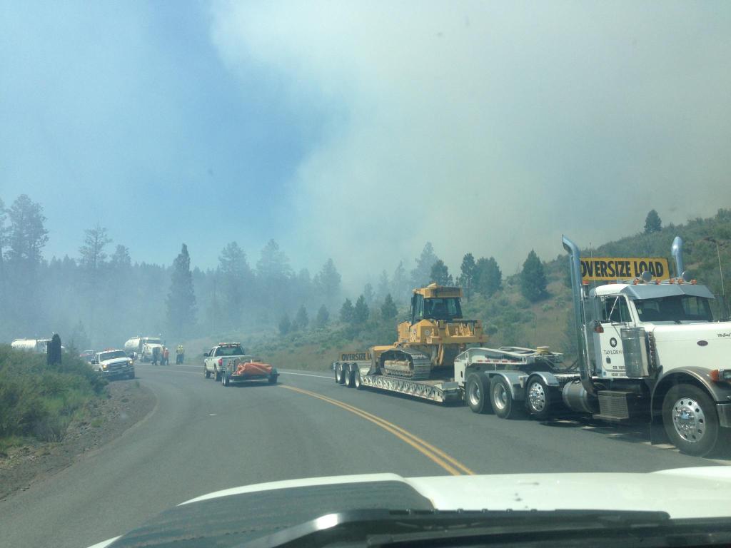
Tuesday, June 30, 2015

6/30/15 Sugarloaf Fire Evening Update

Oregon Department of Forestry
Incident Management Team 1
John Buckman, Incident Commander
 
Contact: Brian Ballou, Information Officer, (541) 621-4156
 
FIRE AT A GLANCE
NIGHT SHIFT
5,016 acres
20 percent contained
Lightning-caused
Night Shift Resources:
3 crews
2 engines
2 water tenders
75 personnel
 
Fire activity was moderate on the Sugarloaf Fire today, with little additional acreage burned outside of the previous fire perimeter. Some interior pockets of unburned fuels were consumed, reducing the chance of a reburn later. Crews were able to establish a fire line along part of the north to northeast edge of the fire. More mopup was completed around the structures along Dick Creek Road.
A Hot Shot crew worked on the Blue Basin Fire near State Route 19, maintaining containment of the fire without damaging any sites in the John Day Fossil Beds National Monument. A crew also suppressed a small lightning fire discovered today, about four miles north of Sugarloaf Mountain. Today this fire team also assumed responsibility for the Schoolhouse Gulch Fire. It is about 2 miles east of Dayville, roughly 100 acres in size, and relatively quiet.
Tonight the fire personnel will lay hoses along the fire lines that the day shift completed on the northeast part of the fire. This area has more trees and other heavy fuels which burn more intensely. The hose lays will be needed to supply enough water to extinguish this part of the fire. Other night shift personnel will continue to patrol the fire, watching for hot spots to extinguish. They will concentrate their efforts near the structures and along Dick Creek Road. A “heavy” helicopter will be available to help with water drops if needed until about 9:00 p.m.
On Wednesday, this fire team will be assuming suppression responsibility for the Corner Creek Fire. It is burning on the west side of the South Fork John Day River about 11 miles south of Dayville. This fire grew several thousand acres today.
The forecast for the rest of the week is for continuing hot weather with low humidity. Winds are a concern, especially in the evenings when “sundowner” winds have been gusting to 20 mph. Some nights the winds haven’t abated until 2 a.m.

Central Oregon Fire EVENING Update, 6/30


Central Oregon Fire EVENING Update

 
PRINEVILLE, Ore. – Firefighters on the Corner Creek Fire (formerly Incident #297) continued to be challenged by high temperatures and low relative humidity today which contributed to rapid wildfire growth.

The Corner Creek Fire located 11 miles south of Dayville, Oregon near the Black Canyon Wilderness, experienced significant growth and is estimated to be 2,500 acres with no containment. A VLAT (Very Large Air Tanker), three tankers, 4 SEATs (Single Engine Air Tankers), and three helicopters have been working on structure protection where the fire has threatened cabins and various outbuildings along Wind Creek. The fire is continuing to push south and west burning in light grass and brush.

At 6:00 a.m. tomorrow morning, Oregon Department of Forestry Team 1 will assume command of the Corner Creek, Sugarloaf and #296 fires. The Sugarloaf Fire is still the largest fire in Central Oregon at 5,016 acres and 20% containment. Incident #296 burning about 1 mile south of Dayville grew to about 65 acres. Firefighters are working on containment.

Firefighters were able to respond quickly to lightning start (#283) on the east end of the Maury Mountains east of Prineville this morning, keeping it under ¼ acre. This fire was a “holdover” from lightning storms that have tracked through Central Oregon in the past week. These holdovers can ignite fires up to 2 weeks after the initial lightning strike so fire crews will remain stationed around Central Oregon to respond as quickly as possible to any new fires.

Red Flag Warnings remain in effect through 9 p.m. tonight for lightning, primarily in areas east of Prineville.


 -END-

VLAT Headed to Corner Creek Fire


A VLAT (Very Large Air Tanker) will be joining the structure protection efforts on the Corner Creek Fire this afternoon. The VLAT is joined by 3 tankers, 4 SEATs (single engine air tankers), and 3 helicopters.

Fire Officials Urge Caution for Holiday Weekend

Fire Officials Urge Caution For Holiday Weekend

BEND– With the Fourth of July holiday fast approaching, firefighters and land managers would like to remind the public to recreate safely on federal public lands this weekend.

Continued hot and dry conditions have contributed to an increase in human caused wildfire activity and a HIGH fire danger rating. Visitors to the national forest are reminded to be “Fire Safe” this holiday and throughout the summer, which includes leaving the fireworks at home.

Fireworks and other exploding targets are prohibited on federal public lands in Central Oregon, including the Deschutes and Ochoco National Forests, the Prineville BLM, and the Crooked River National Grassland. 

“There’s an appropriate time and place for fireworks—but that’s not on federal lands during fire season,” said Alex Robertson, Fire Staff Officer for the Central Oregon Fire Management Service. “Fireworks are restricted on federal lands and we ask that people respect that. Already we are seeing abnormal fire growth in wildfires across Central Oregon with fires growing bigger, faster. So while we want the public to enjoy a fun and safe holiday and summer, we also will continue to work closely with our partners at state and local levels to ensure that when it becomes necessary, we implement precautionary measures to protect our forests and communities.”

National Forest System lands in Central Oregon are not under public use restrictions right now but campers are reminded to never leave their campfire unattended and to fully extinguish campfires with water and shovel until the coals are cool to the touch. Fires that appear to be out may smolder for several days and pick up again during the next wind event. The smallest spark has the potential to cause significant damage.

Always crush cigarettes dead out, ensure that your vehicle has a properly installed spark arrester that is operational, and stop and park only in areas clear of vegetation.

Discharging fireworks on federal public lands is punishable by a fine of up to $5,000 and a sentence of up to six months in jail. 
                             

-END-

6/30/15 - Sugar Loaf Fire Update

Oregon Department of Forestry                                                                                     
Incident Management Team 1                                                                                          
John Buckman, Incident Commander                                                                                    
Contact: Brian Ballou, Information Officer, (541) 621-4156                                                
 
FIRE AT A GLANCE

DAY SHIFT
 5,016 acres
20 percent contained
Lightning-caused
 
Resources:
7 crews
12 engines
2 bulldozers    
2 water tenders
232 personnel
                                                                                                                    
The Sugarloaf Fire is expected to burn more intensely today. The moisture from Sunday’s thunderstorms has dissipated, resulting in drier fuels and lower relative humidity. The amount the fire spreads will be largely influenced by winds and topography. The primary fuels inside the fire perimeter are grasslands and juniper trees in the low country and pine and fir stringers on the upper slopes. This lightning-caused fire covers 5,016 acres and is 20% contained.  There are 232 persons assigned to day shift on the fire.
On Monday, progress was made on extinguishing areas around structures on Dick Creek Road.  Helicopters were used to cool an area with steep slopes and heavy fuels above Johnny Creek on the north edge of the fire. Dozers worked on creating and improving fuel breaks along the north and east edges of the fire.
Steep slopes and limited access are restricting the suppression efforts on several areas of the fire. Due to steep, broken terrain, fire lines are being dug by hand along parts of the northeast and south edges of the fire. Unburned pockets of fuel inside the current fire area also continue to burn. Engines are patrolling the perimeter roads and the Dick Creek Road to extinguish hot spots near structures. Approximately 12 structures in the Dick Creek Road area were threatened by the fire.
Yesterday this fire team assumed command of a new fire that started to the west of the Sugarloaf Fire. The Blue Basin Fire burned about 400 acres east of State Route 19, largely within the John Day Fossil Beds National Monument. Fire personnel will be working to control this fire without damaging the special resources in the Monument.  This is a human caused fire, under investigation.
The Oregon Department of Forestry’s Incident Management Team 1 assumed command of the Sugarloaf Fire at 6:00 a.m. yesterday. The team is working for the Bureau of Land Management, the John Day Fossil Beds National Monument and ODF’s Central Oregon District. The fire is located approximately 8 miles north of Dayville. This incident is being managed as a full suppression fire. Efforts are being made to contain the fire and minimize private acreage burned.
Sensitive sites within the fire area include nationally recognized fossil beds, anadromous fish spawning beds and golden eagle nesting sites. Firefighters are using care to minimize suppression impacts in these areas while they take the actions necessary to contain the fire.
Hazards confronting firefighters include rattlesnakes, lightning, and hot, dry weather. High winds around thunderstorms may cause erratic fire behavior and rapid movement.

6/30/15 Central Oregon Morning Fire Update

Fire crews continued to work on several fires burning around Central Oregon and firefighters remain vigilant for any holdover fires from the lightning storms that moved through the area last weekend and early this week. Ten new fires were reported yesterday, with two growing larger.

The largest of the new fires is the Corner Creek Fire (Incident #297), burning 11 miles south of Dayville, Oregon near the Black Canyon Wilderness. The fire, burning in light grass and brush, grew to 850 acres overnight. In addition to firefighters on the ground, suppression efforts will be helped by heavy airtankers, single engine air tankers (SEATs) and helicopters today. Firefighters will be challenged today by high daytime temperatures and steep slopes with limited access. The cause is lighting.

The second fire, Incident #296, burning about 1 mile south of Dayville grew to about 65 acres yesterday. The Type 2 team currently managing the Sugar Loaf Fire has assumed command of this incident.

The largest fire in Central Oregon is the Sugar Loaf (incident #268), which continues to be managed by a Type 2 Incident Management Team. Information on Sugar Loaf will be provided on Inciweb.

As temperatures increase through the week, firefighters expect more lightning holdover fires. These fires occur when lightning strikes a tree and starts a fire that smolders in the needles and debris underneath the tree where it’s protected from any rain that falls. As temperatures increase and nearby ground dries out, the fire flares up and can spread. Holdover fires commonly occur up to two weeks after a storm.

With the potential for fighters to be busy with lightning fires, fire officials want to remind everyone to be extremely cautious with fireworks, and to use care when recreating on public land. Make sure campfires are allowed, and always put them out when you leave or before you go to bed. Avoid traveling on roads with vegetation down the middle – this can accumulate underneath a vehicle and cause it to catch fire.

Monday, June 29, 2015

6/29/2015 - Central Oregon Evening Fire Update

FIRE NEWS--Central Oregon Interagency Dispatch Center
For Immediate Release: June 29, 2015 8:00 p.m.


Central Oregon Fire EVENING Update


PRINEVILLE, Ore. – Firefighters are continuing to respond to several fires across Central Oregon tonight, the largest fire is 100 acres on the southeast border of Black Canyon Wilderness with no containment at this time.

As afternoon winds picked up, firefighters engaged numerous fires on and near the Ochoco National Forest and Prineville BLM. The second largest wildfire of the day is Incident #296, which was originally reported at 30 acres 1 mile south of Dayville, Oregon. Several engines and single engine air tankers are working to stop forward progress at the head of the fire and protect structures.

Crews also responded to a 7 acre fire 4 miles west of Mill Creek Wilderness that has been lined by firefighters who have progressed into mop-up.

The largest fire in the area is still Sugarloaf (incident #268), which remains at 4,612 acres. Crews continue to make progress constructing a fireline and the incident remains 20 percent contained. The fire is located about 8 miles north of Dayville, OR and is burning in a combination of shrub and light grass. This incident also absorbed a new start outside of the fire area immediately north of John Day Fossil Beds National Monument. No further information on this incident is available this evening.

All other starts, including two on the Deschutes National Forest, have been held to under half an acre.

-END-

6-29-15 Sugarloaf Wildfire Update

Oregon Department of Forestry
Incident Command Team 1
John Buckman, Incident Commander


FIRE AT A GLANCE
DAY SHIFT

4,612 acres
20 percent contained
Lightning-caused

Resources:
6 crews
20 engines
3 bulldozers
2 water tenders
203 personnel

Contact: Brian Ballou, Information Officer, (541) 621-4156

The Oregon Department of Forestry’s Incident Management Team 1 assumed command of the Sugarloaf Fire at 6:00 a.m. today. The team is working for the Bureau of Land Management, the John Day Fossil Beds National Monument and ODF’s Central Oregon District. The fire is located approximately 8 miles north of Dayville. The Sugarloaf Fire’s incident command post is located at the Dayville School.

A few rain showers associated with a passing thunderstorm have slowed fire activity this morning, but much work remains to be done to contain the Sugarloaf Fire. The primary vegetation fuels inside the fire perimeter are grasslands and juniper trees in the low country and pine and fir stringers on the upper slopes.
The greatest fire activity is along the northeast flank of the fire, and the south and southwest flanks are relatively cool.

This incident is being managed as a full suppression fire. Efforts are being made to contain the fire and minimize private acreage burned. Fireline construction continues along the north flank. Engines are patrolling the perimeter roads and the Dick Creek Road, which cuts through the middle of the burned area, to extinguish hot spots near structures.

Approximately 12 structures in the Dick Creek Road area were threatened by the fire and some residents left the area on Sunday. Residents have since returned home. No primary structures burned.

A Red Flag Warning remains in effect for the fire area today. Thunderstorms may develop again through the afternoon and bring scattered showers. Wind is expected to be 10 mph from the northwest, but may be stronger and gustier around thunderstorms.

Sensitive sites within the fire area include nationally recognized fossil beds, anadromous fish spawning beds and golden eagle nesting sites. Firefighters are using care to minimize suppression impacts in these areas while they take the actions necessary to contain the fire.

Hazards confronting firefighters include rattlesnakes, lightning, and hot, dry weather. High winds around thunderstorms may cause erratic fire behavior and rapid movement.


Sunday, June 28, 2015

6/28/15 Central Oregon Fire Evening Update

Fire crews continued to work on several fires burning around Central Oregon, and three new fires were reported today. The largest of the new fires is incident #285, a two-acre fire started by juveniles playing with fireworks on Round Butte, 5 miles southwest of Madras. Fire crews responding from the Prineville BLM and Jefferson County rapidly contained this incident; however, it serves of a reminder about how quickly fireworks can start a fire. Fireworks should only be ignited by an adult, in a safe area clear of vegetation, and only where they are legally allowed. Restrictions vary by city and county, so verify local regulations before using fireworks.

Fire crews are responding to a new lightning start (#283) on the east end of the Maury Mountains east of Prineville, initially reported at ¼ acre, and a single-tree fire south of milepost 53 on Highway 20. Lightning storms currently tracking north through Crook and Wheeler Counties may start additional fires overnight or in the next several days.

The largest fire, Sugarloaf (incident #268), continues to grow to the south. Heavy smoke lifted this afternoon, allowing a helicopter to map the perimeter; the fire is 4,095 acres. Crews are making progress constructing a fireline, and the incident is now 20 percent contained. The fire is located about 8 miles north of Dayville, OR and is burning in a combination of shrub and light grass. One firefighter suffered from dehydration today but is receiving treatment and doing well. The residents in the Dick Creek Road area have been allowed back in their homes; however, they remain ready to leave in the event that conditions change again.

A Type 2 Incident Management Team will assume command of this fire tomorrow morning and a fire camp has been established in Dayville, Oregon to house the almost 250 personnel working on this incident.

In addition to the Sugarloaf fire, firefighters are working on two other fires. The Buck Creek Fire (#250) located 18 miles northeast of Hampton, Oregon remains at 250 acres and is 90 percent contained. The Bear Creek Fire (#251) located 7 miles south of Prineville Reservoir near Bear Creek Butte held at 30 acres today and is now 100 percent contained.

Red Flag Warnings remain in effect through 9 p.m. tonight for lightning, primarily in areas east of Prineville. Fire crews will remain stationed around Central Oregon to respond as quickly as possible to any new fires.

6/28/15 - Central Oregon Fire MORNING update

Fire crews spent the night working on several fires burning around Central Oregon. No new fires have been reported overnight, although firefighters, lookouts and reconnaissance planes will remain vigilant today for any new starts from recent lightning storms.

The largest fire, Sugarloaf (incident #268), continues to grow and is now 5,500 acres. The fire is located about 8 miles north of Dayville, OR and is burning in a mix of shrub and light grass. Steep slopes and afternoon winds challenged firefighting efforts and contributed to fire growth. The fire is burning in a mix of public and private land and continues to threaten several structures in the area. No injuries have been reported; however, the fire did burn one vehicle and one outbuilding. The evacuation for residents within the Dick Creek Road area ordered by the Grant County Sheriff’s Department remains in effect.

More than 200 firefighters have responded to this incident, and a Type 2 Incident Management Team has been ordered to assume command of this fire. Crews will be assisted by a Type 1 and Type 2 helicopters today and airtankers (both single engine and heavy) are available in the event the fire moves toward structures.

In addition to the Sugarloaf fire, firefighters are working on several other fires. The Buck Creek Fire (#250) located 18 miles northeast of Hampton, Oregon held at 250 acres overnight and the Bear Creek Fire (#251) located 7 miles south of Prineville Reservoir near Bear Creek Butte held at 30 acres overnight. Crews will continue to hold and improve containment lines on these fires today. No estimate of containment is currently available.

Red Flag Warnings remain in effect through 9 p.m. tonight for lightning, primarily in areas east of Prineville. Fire crews will remain stationed around Central Oregon to respond as quickly as possible to any new fires. As the 4th of July holiday approaches, fire officials also want to remind everyone that possession or use of fireworks on Forest Service or BLM land is illegal.

6/27/15 Central Oregon Fire EVENING Update

In the past 24 hours fire fighters have responded to 21 new fires across Central Oregon, with that number expected to grow as new fires are found or are ignited by additional lightning. Most fires remained small and currently are being mopped up or have been contained.

The largest fire, and of greatest concern, is a fire (#268) burning on BLM Prineville District lands, approximately 9 miles north of Dayville, Ore, near Kimberly, Ore. The fire, which quickly grew to over 300 acres, is burning in the Dick Creek Road area in grass and shrub. Structures are being threatened by the fire and residents within the Dick Creek Road area quickly have been evacuated by the Grant County Sheriff’s Department.

Several air tankers, helicopters and crews were dispatched to the fire (#268); however, air tankers were hampered by strong winds late in the afternoon. A Type 3 Team also was assigned to the fire in the afternoon. County resources and firefighters with Central Oregon Fire Management Services (COFMS) will continue to respond to the fire.

Another fire, near Mill Creek Wilderness on the Ochoco National Forest also caused concern early in the afternoon. Firefighters were able to get a handle on the fire and at this point have been able to keep the fire small (<10 acres).

The two largest fires at the beginning of today, the Bear Creek Fire and the Buck Fire, burned grass and shrub also on BLM Prineville District lands around Brothers, Ore. The Bear Creek Fire was approximately 75 acres and the Buck Fire was approximately 250 acres. Both fires were being held and mopped up by the end of the day.

Smoke columns from fires in the Paulina Lake area of Newberry National Volcanic Monument of the Deschutes National Forest were very visible during the day because they were burning heavy timber; however, they were easily contained and kept small.

With more lightning expected overnight combined with extremely dry fuels and gusting winds, fire official expect a need for continued fire response over the next several days.

Wednesday, June 17, 2015

Central Oregon FS/BLM lands will enter Industrial Fire Protection Level 2 on Friday

Beginning at 12:01 a.m. on Friday, federal public lands across Central Oregon will limit the hours of operation for chainsaws and certain other activities in order to better protect against wildfire danger.

These protections extend to all lands managed by the Deschutes and Ochoco National Forests, the Crooked River National Grassland, and the Prineville District of the BLM.

With a lack of precipitation and warming temperatures, fuel conditions continue to dry out across the region.  In recent weeks, firefighters have already responded to multiple natural and human-caused wildfires throughout Central Oregon.

Under Industrial Fire Protection Level 2, also known as “Partial Hootowl,” the following may operate only between the hours of 8 p.m. and 1 p.m. local time:
• power saws except at loading sites;
• cable yarding;
• blasting; and
• welding or cutting of metal.

A loading site is defined as a place where any product or material (including, but not limited to logs, firewood, slash, soil, rock, poles, etc.) is placed in or upon a truck or other vehicle.

Industrial Fire Protection Levels do not regulate the use of campfires, which are handled under Public Use Restrictions.

Currently, the only campfire restrictions on federal public lands in Central Oregon are annual restrictions along BLM rivers.


For more information, contact your local Forest Service or BLM office.

Friday, June 12, 2015

Friday morning update: Shevlin Park Fire

Crews are expected remain on scene through Friday to ensure that there are no flare ups.  Drivers are urged to use caution in the area, as there will still be some large firefighting equipment moving around the scene.

The fire, which started near the Tumalo Irrigation intake on Tumalo Creek, within the confines of Shevlin Park, burned 8-10 acres before being controlled by crews from Bend Fire, Oregon Department of Forestry, BLM and the Deschutes National Forest.  A BLM helicopter provided several water drops and a large air tanker circled the scene for about an hour before finally being released from the area.

A mutual aid task force from departments around the county were requested and dispatched.  These units patrolled through the subdivisions to the south of the fire.

During the incident, Shevlin Park Road was closed near McClain Road and three subdivisions south of the park were placed on a Level 1 Evacuation advisory.  At the height if the incident, it is estimated that 90 people were on scene, although the number was reduced to 40 overnight, after the fire was contained.

Thursday, June 11, 2015

Shevlin Park Fire Map

Use this link to see a map of the fire and evacuation area...


Shevlin Park Fire Update

Update from the Shevlin Park Fire command post. The fire is approximately 8 to 10 acres in size it's in the canyon of Tumalo Creek moving to the east towards Bend. Crews on the ground feel they are making good progress and the growth has been stopped. There are 19 fire units working the fire.  Crews from BEND FIRE, USFS, ODF, DCSO, BPD, DC roads AND Taylor NW are on hand. Level one evacuations are still in effect for the neighborhoods off of Shevlin Park Road.

On scene at the Shevlin Park Fire...

Embedded image permalink

A view from the road of the fire near Shevlin Park.

Shevlin Park Fire Evacuation info

There is a LEVEL 1 pre-evacuation notice to the Three Pines and Shevlin subdivisions on both sides of Shevlin Park, west of McClain.


Wildfire Evacuation Levels Explained

Level 1: Be Ready

There is an incident in the area. Residents are advised of the level 1 evacuation and are asked to leave if they need additional time to exit an area or have health conditions (especially respiratory conditions that could be made worse by smoke). Residents are encouraged to move livestock and pets out of the area, and to prepare for a full evacuation. Evacuations are voluntary, but residents are encouraged to leave if concerned. There will be no road closures in effect in most cases.

Level 2: Leave Soon

Residents are notified there is a full evacuation and are informed to leave. Evacuations are mandatory and entry to evacuated areas may be denied. Residents are encouraged to evacuate as soon as possible. Residents MAY have time to gather necessary items, but doing so is at their own risk.

Level 3: Leave Immediately!

Residents are notified there is immediate and imminent danger, and they should evacuate immediately. DO NOT delay leaving to gather any belongings or make efforts to protect your home. Leave immediately and as quickly as possible. Doing so will not only support your safety, but will allow firefighters to best maneuver resources to combat the fire.


Ready, Set, Go!

Don’t let the first time you educate yourself on wildland fire be in the aftermath. Join with us and be a part of Ready, Set, Go! Ready, Set, Go! is designed to teach individuals how to best prepare themselves and their properties against nature’s threats, and how to be best prepared to evacuate.

The Ready, Set, Go! initiative is a three step process, or action plan, to prepare properties long before a fire is upon you; get set to depart from ones home; and to understand the role of evacuation in our area. The initiative significantly increases the safety of the homeowner and family. Not to mention, it allows the firefighters to best do their job of extinguishing the fire, thus increasing the chance of saving homes and loved ones.

Ready

Make a list of your 5P’s: People, Pets, Pills, Photos and important Papers.Shut off natural gas and propane.Place metal (not wooden) ladders against the side of your house.If time permits, remove combustibles (patio furniture, firewood, etc.) within 30 feet of your home.If you have sprinklers (with adequate water supply), place them around your home, connected and ready to be turned on.Put on any protective clothing and gear you are not already wearing.Close windows and doors to the house to prevent sparks and embers from blowing inside. Close all doors inside the house to prevent draft.Take down your drapes and curtains and close all blinds to deflect heat.Leave exterior and interior lights on to offer visibility to responders.Fill all bathtubs, sinks and other containers with water to deflect heat.

Set

Take a deep breath and remember your plan. Lives always take priority over property.Face your car toward the street and close all windows. Keep the keys handy.Load your 5P’s into the car.Wear protective clothing made of natural fabrics such as heavy denim, cotton, and pure wool to shield you from heat, embers and flames. Wear sturdy shoes, a long-sleeved shirt tucked into pants, hat, and a handkerchief. Have thick canvas or leather gloves, and light-colored goggles on ready.As you leave, post a visible form of notification that identifies that you have evacuated. Hang a white cloth at the end of your driveway. If you have time, write “evacuated” on it.

Go!

Tune in to the local news radio station and listen for instructions.Obey orders of law enforcement and fire department officials.Follow the emergency instructions regarding evacuation routes. Your normal route may not be the safest.Drive with your headlights on for visibility and safety.Do not block access to roadways for emergency vehicles or other evacuees.Do not abandon vehicles on the roadway.Do not stop to let pets have a break.Drive calmly, obey the rules of the road and pay special attention to fire trucks.

The Ready, Set, Go! Program is the result of a nationwide discussion on how to protect homes and lives in what the fire service calls the Wildland-Urban-Interface – where development meets natural vegetation – and the Ember Zone, an area where the wind driven ember fallout from a wildland fire can threaten property and lives. The program was developed for national roll out by the International Association of Fire Chiefs (IAFC) with support from US Forest Service, US Fire Administration, Department of the Interior, Firewise and The Insurance Institute for Home Business Safety (IBHS).


For more information on the Ready, Set, Go! initiative please visit http://www.wildlandfirersg.org/. ##

Shevlin Park Brush Fire

There is a brush fire. About 10 acres in size and growing, burning just downstream from Aspen Hall in Shevlin Park.  The fire is burning in the canyon of Tumalo Creek in moderate fuels.  Oregon Department of Forestry, Deschutes National Forest personnel and the Bend Fire Department are currently on scene.  10 engines and a helicopter are on scene.  They are applying water to the fire and using dozers to build fire line.

We are asking people to stay away from the area.  Deschutes County Deputy Sheriffs are closing Shevlin Park Road at the 3 Pines subdivision so that crews can operate more effectively and safely.


FIRE NEWS--Central Oregon Interagency Dispatch Center
For Immediate Release:  June 11 , 2015 10:00 A.m.


Central Oregon Fire MORNING Update

PRINEVILLE, Ore. – Firefighters will continue suppression efforts today on multiple fires, most of them small, across Central Oregon, and most of them the result of recent lightning activity that accompanied Tuesday’s thunderstorms.

Two lightning-caused wildfires near Twickenham, approximately 14 miles southeast of Fossil, Ore., now cover about 200 acres. The fires are burning in juniper, grass and brush fuels on both private and BLM-administered land. The fire suppression response includes multiple engines and smokejumpers.

On the Deschutes National Forest, firefighters continue the suppression response on a wildfire located yesterday approximately 9 miles west of Sunriver and 10 miles south of Mt. Bachelor, burning in steep timber and brush. The updated size for this fire is approximately 25 acres. Multiple firefighters and a Type 2 helicopter are responding. Cause of the fire is undetermined.

Firefighters are also responding to multiple other, small, lightning-caused single-tree fires across the Deschutes and Ochoco National Forests and the Prineville BLM. More incidents are expected throughout the day as temperatures increase and holdover fires from recent lightning activity produce enough smoke to be spotted and located.

The National Weather Service has issued a Red Flag warning for much of Central Oregon, to remain in effect through 8pm Friday. A Red Flag warning indicates a high likelihood for critical fire weather behavior, which includes strong winds, low relative humidity, and warm temperatures.


-END-

Wednesday, June 10, 2015

Central Oregon Fire Update June 10, 2015

Contact:  Media Desk:  541-416-6811           Email address:  Centralorfireinfo@gmail.com
Twitter:  @CentralORfire                              For more information visit: CentralORfireinfo.blogspot.com


FIRE NEWS--Central Oregon Interagency Dispatch Center
For Immediate Release:  June 10 , 2015 6:00 p.m.


Central Oregon Fire Update

PRINEVILLE, Ore. – Firefighters in Central Oregon are currently responding to multiple incidents, many the result of recent lightning activity that accompanied yesterday’s thunderstorms across the region.

The largest incident is a 100-acre lightning-caused wildfire near Twickenham, approximately 14 miles southeast of Fossil, Ore. Incident 177 is burning in juniper, grass and brush fuels on both private and BLM-administered land. The fire suppression response includes multiple engines and smokejumpers.

On the Deschutes National Forest, firefighters are responding to Incident 172, approximately 9 miles west of Sunriver and 10 miles south of Mt. Bachelor. The 7-acre fire is burning in timber and brush. Multiple firefighters are hiking into the fire and a Type 2 helicopter is in response. Cause of the fire is undetermined.

Firefighters are currently responding to multiple other, small, lightning-caused single-tree fires across the Deschutes and Ochoco National Forests and the Prineville BLM.

The National Weather Service has issued a Red Flag warning for much of Central Oregon, to remain in effect through 8pm Friday. A Red Flag warning indicates a high likelihood for critical fire weather behavior, which includes strong winds, low relative humidity, and warm temperatures.


-END-

Saturday, June 6, 2015

Closures for Saturday's RX Burn in West Bend

As a reminder, you can always check to see the status of trails in West Bend by checking out this West Bend map. Bookmark the site--we'll be using this one for years!

West Bend Live Map

Thursday, June 4, 2015

Prescribed Burn Planned Adjacent to Black Butte Ranch

              
Prescribed Fire Planned Adjacent to Black Butte Ranch

SISTERS – Warmer weather and favorable winds are lining up for fuels specialists on the Sisters Ranger District to conduct a prescribed burn tomorrow. Up to 42 acres could be burned ¼ mile east of Black Butte Ranch and one mile south of Highway 20 in the Glaze Meadow area. 

The prescribed fire is part of the Glaze Forest Restoration Project, a project which was accomplished through close collaboration between the Forest Service, public, and representatives from both the environmental and timber communities.    

Due to the location of these units, the public could see smoke and drivers may experience smoke impacts on Highway 20 and throughout Black Butte Ranch. For all prescribed fires, signs will be posted on significant nearby Forest roads and state highways that could be impacted.  No road closures are anticipated with this project.

Black Butte Ranch will likely be impacted by smoke as a result of this project. Residences and businesses in the area are advised to keep their windows and doors closed during the night hours to avoid any unintended smoke impacts. 

Fuels specialists will follow policies outlined in the Oregon Department of Forestry smoke management plan, which governs prescribed fires, and attempts to minimize impacts to visibility and public health. For more information, visit the Ochoco/Deschutes website at www.fs.usda.gov/deschutes  and follow us on twitter @CentralORFire. 

Wednesday, June 3, 2015

Prescribed Burning Will Close Phil’s Trailhead Parking Area on Friday Second Prescribed Burn on Saturday Will Be North of “Good Dog” Area

     
Prescribed Burning Will Close Phil’s Trailhead Parking Area on Friday
Second Prescribed Burn on Saturday Will Be North of “Good Dog” Area
BEND – Given continued favorable weather conditions, fuels specialists are scheduled to ignite two prescribed burns on Friday and Saturday in the West Bend Project area.

On Friday, a 119 acre prescribed burn will take place adjacent to Phil’s trailhead with ignitions beginning at 11:00am. Phil’s Trailhead parking area will be closed on the day of the burn due to the need for fire vehicles and personnel to be in close proximity to the burn area.  Forest Road 4604, which accesses the trailhead from Skyliners Road, will also be closed to the public on the day of the burn. The trail system will largely remain open on Friday with the exception of an approximately one mile trail closure on Skills Loop that will be in place for up to two days.  Mountain bikers and hikers can still access the trail system from other access points but are also reminded to take advantage of other mountain biking opportunities in the area, including the trail system at Wanoga Sno-Park, which is located approximately 20 minutes from Phil’s Trailhead.

The prescribed burn slated for Saturday, June 6, is a 136 acre unit located on the western edge of Bend adjacent to Cascade Lakes Highway, north of and across the highway from the “Good Dog” area. Forest Road 010 will be closed during the burn which is scheduled to begin at 11:00 a.m. and should be completed by 1:00 p.m.  Trail closures will be in place beginning Saturday including COD from Jct. 50 near Entrada to ELV at Jct. 20.

The winds forecasted for both burn areas are expected to push smoke up and over Bend, which will limit impacts to the community. However smoke will be highly visible from the Bend and the surrounding areas.  Residences and businesses in the area are advised to keep their windows and doors closed during the night hours when there is the greatest potential for smoke in the area to linger.  Fuels specialists will follow policies outlined in the Oregon Department of Forestry smoke management plan, which governs controlled burns, and attempts to minimize impacts to visibility and public health.

Hazards, including fire weakened trees and areas of hot ash, will exist in the burn area for 1-2 weeks or more after burn implementation.  It is advised that recreationists remain on the trails and roads, and that dogs remain on leash when travelling around the burn area. If smoke drifts on to roads, motorists should slow down, turn on headlights, and proceed with care.  The smoke will dissipate after ignitions have been completed, but smoke could be visible in the burn area for an additional 2-3 days. Fuels specialists will be monitoring the burn area through the weekend and into next week.


Background:
The West Bend Vegetation Project is the first project to be implemented through a partnership with the Deschutes Collaborative Forest Project (DCFP), an organization bringing a diverse group of stakeholders together with the Forest Service to design and plan treatment options for highly valued and historically controversial areas. DCFP was created through the Collaborative Forest Landscape Restoration (CFLR) Program in 2010 which awarded the Deschutes National Forest with a 10-year, $10.1 million grant to restore 145,000 acres of forest in Central Oregon.  In the summer of 2013 the restoration area was approved for an expansion, bringing the total to approximately 257,000 acres and stretching from Black Butte and Bend to Sunriver and Mt. Bachelor.
Follow us on twitter @CentralORFire.